
Published Thu 9th Oct 2025
Infrastructure owners and engineers in many parts of the world are facing up to the challenges presented by a warmer, wetter climate. Flood events are becoming more frequent, causing significant damage, delay and disruption. Surface water and debris can block roads and wash away bridge foundations, in residential areas flooding can threaten lives and livelihoods, and on railways it can damage track, signalling, power and comms infrastructure. Earthworks and slopes are especially vulnerable, with excess water reducing stability and increasing the risk of landslides and debris flows.
Ground drainage is the primary tool used to manage surface and subsurface water movement. Asset owners such as Network Rail are committed to invest in upgrading drainage infrastructure, but this is a slow and expensive process, so the focus must remain on managing existing assets to optimise their performance and to detect problems before they become critical.
Challenge
Data relating to water level, flow and silting have traditionally been gained by visual or in-pipe surveys conducted on a periodic basis, providing data that are valid only at a single point in time. Because site conditions can change in a short (sub-hour) time frame, there is a need for more frequent or continuous data updates, with automation of systems to trigger alerts if thresholds are breached. Provision of such systems is challenging because sites are typically remote and without mains power, most drainage infrastructure is hidden below ground and any instruments placed inside catchpits, pipes or culverts must be extremely rugged and durable.
A New Approach to Flood Monitoring
Engineers at Senceive have developed a modular automated wireless alerting system to provide near real-time data for multiple years with minimal maintenance. Using wireless remote monitoring technology these systems can be integrated with slope movement monitoring instruments. Multi-sensor wireless systems in remote locations provide near real-time, continuous data to support flood risk management.
Such a drainage monitoring system may include radar- or laser- based water level sensors, weather stations, soil moisture probes and piezometers (for groundwater characterisation), and automated cameras. Solutions can be tailored for the specific needs of a site and easily adapted as those needs evolve. As an example, soil moisture can be monitored at the surface with a simple shallow probe, or at multiple depths to a metre or more using a multi-sensor probe. For analysis of deeper groundwater conditions multiple piezometers can be installed in a borehole.
The cameras are smart IoT devices that automatically send images of the site when requested or when triggered by out-of-threshold readings from other sensors. Decision making can be accelerated and false alerts eliminated because engineers and asset owners can see what’s happening on site within three or four minutes of an alert. This is hugely valuable in the context of railways where the cost of temporary speed restrictions or line blockages can be significant. In the UK, Network Rail is liable to compensate train operating companies (TOCs) for delay minutes, with severe disruptions clocking up so-called Schedule 8 charges of hundreds of thousands of pounds in a few hours. Access to virtually real time photographs long before a person can reach the site can help protect people where there is a real risk, but keep trains moving if site conditions permit.
Most Senceive monitoring equipment is battery or solar powered and data transmission uses the cellular network, so no fixed electricity supply or communications infrastructure is needed. It is therefore suitable for use in remote and inaccessible locations.
Whilst most Senceive users choose the Flatmesh™ communications platform because of its responsiveness and flexibility, there is also the option of a GeoWAN™ installation which can provide coverage of very large (multi-kilometre) areas from a single cellular gateway.
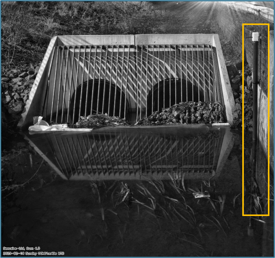
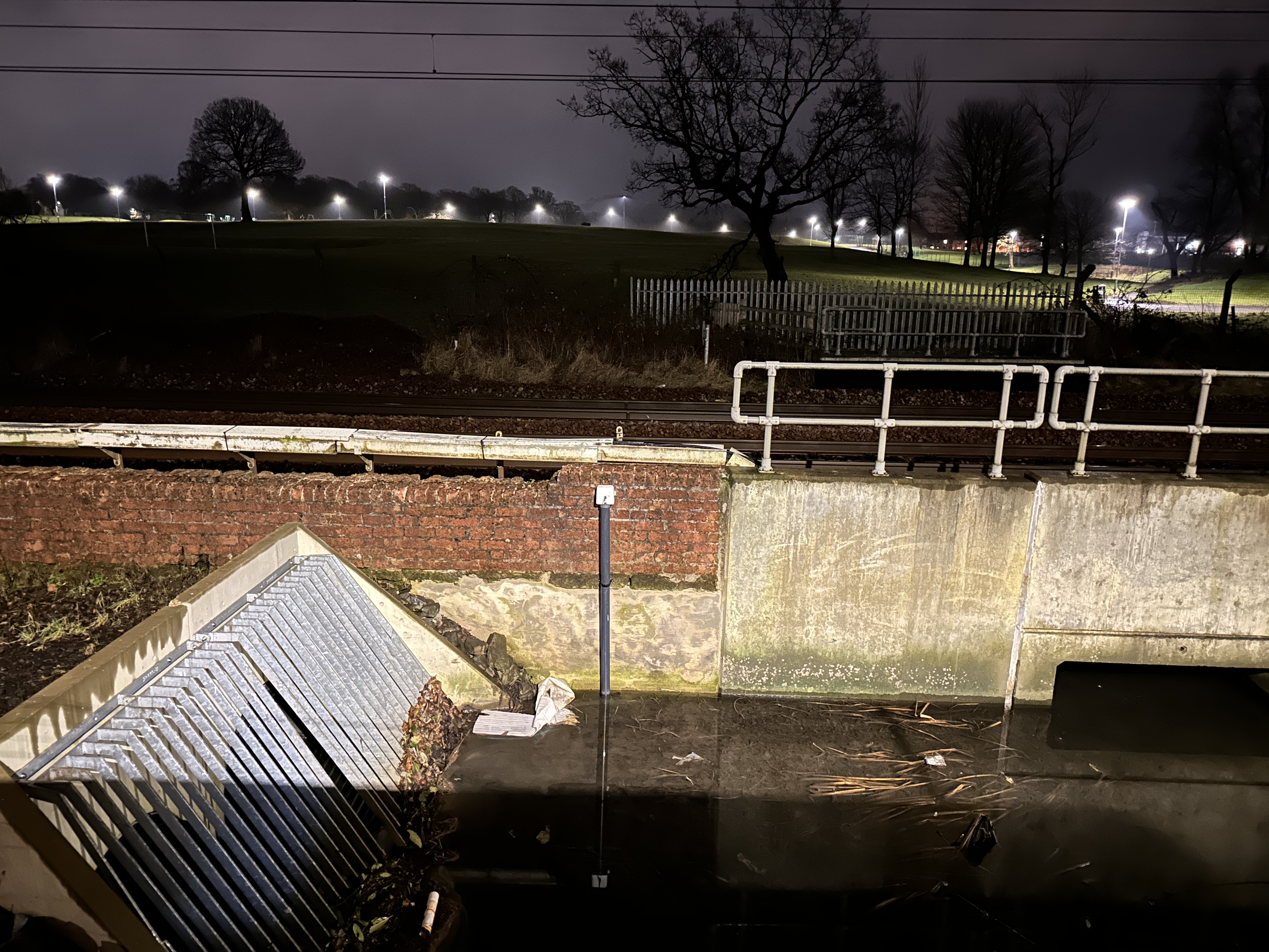
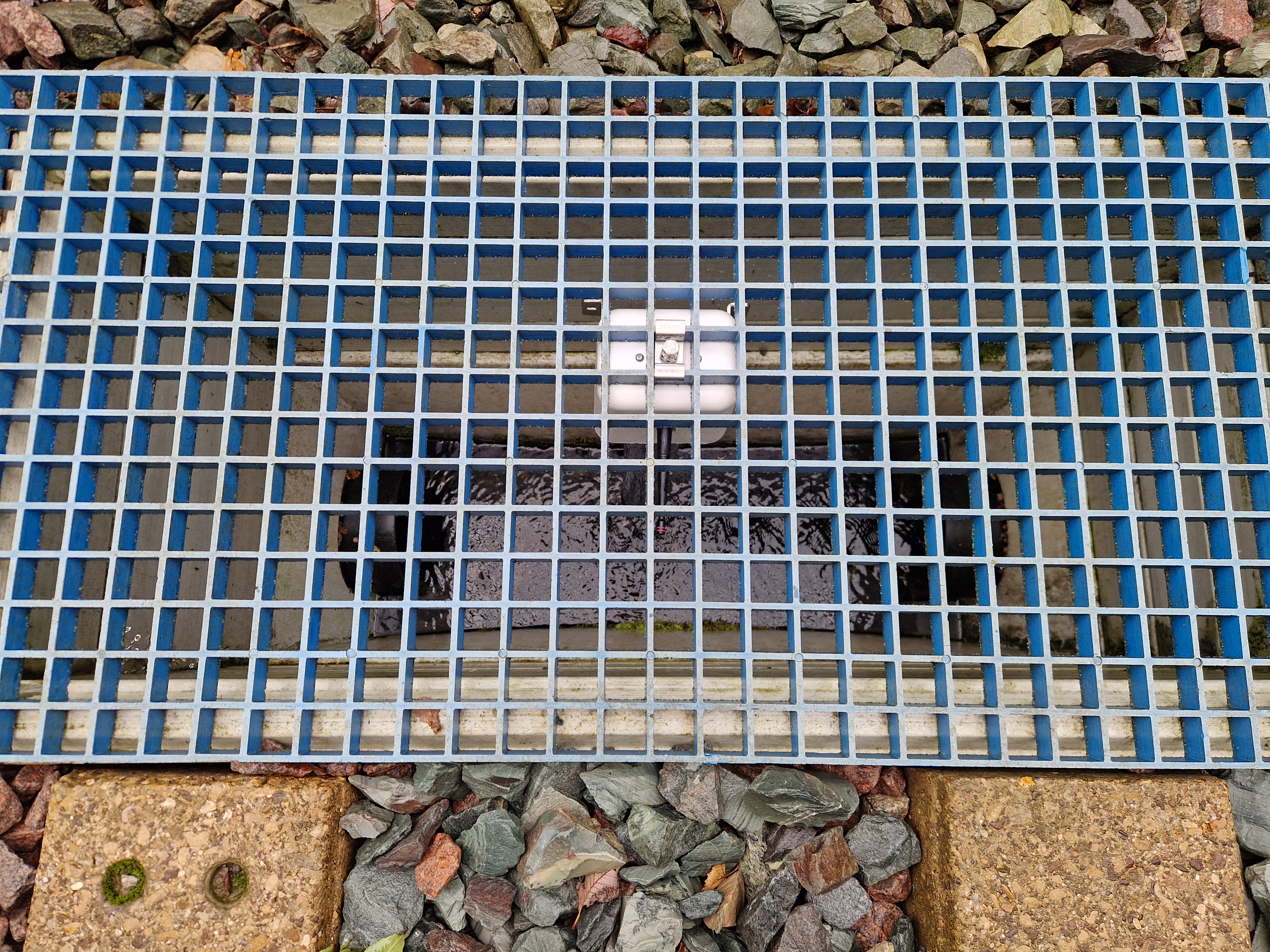
Camera installed as part of an integrated water level monitoring system. Rising water levels detected by a laser sensor (in yellow box) will trigger an alert and send an image to remote stakeholders.
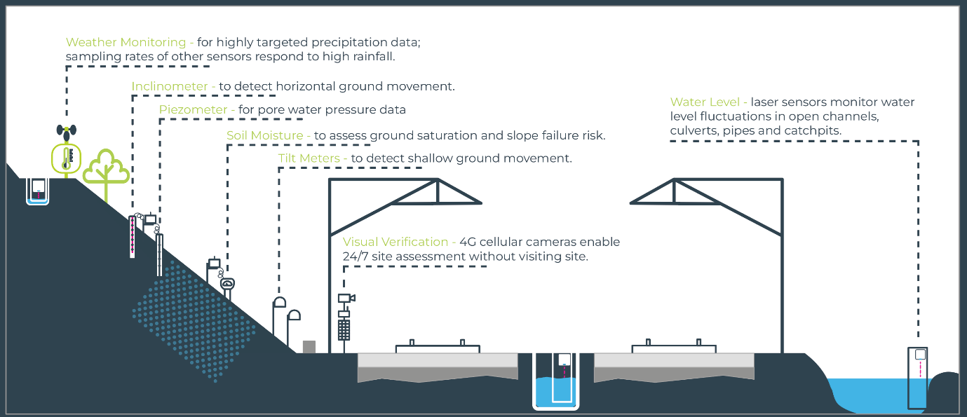
A growing range of sensors may be combined to suit site specific requirements
Case Study: Drainage Monitoring in South London
A track drainage system in south London had been prone to blockage and flooding, presenting risks to a nearby substation. A programme of drainage cleaning and remediation was carried out and Network Rail commissioned monitoring to determine its effectiveness:
-
Laser Water Level Monitor inside the manhole chamber to monitor water levels.
-
Solar-Powered 4G Camera: Positioned above the manhole for near real-time visual verification of overflow events, day and night.
-
4G Cellular Gateway: To securely transmit data to the WebMonitor cloud-based portal – providing instant access to continuous water level readings and camera images.
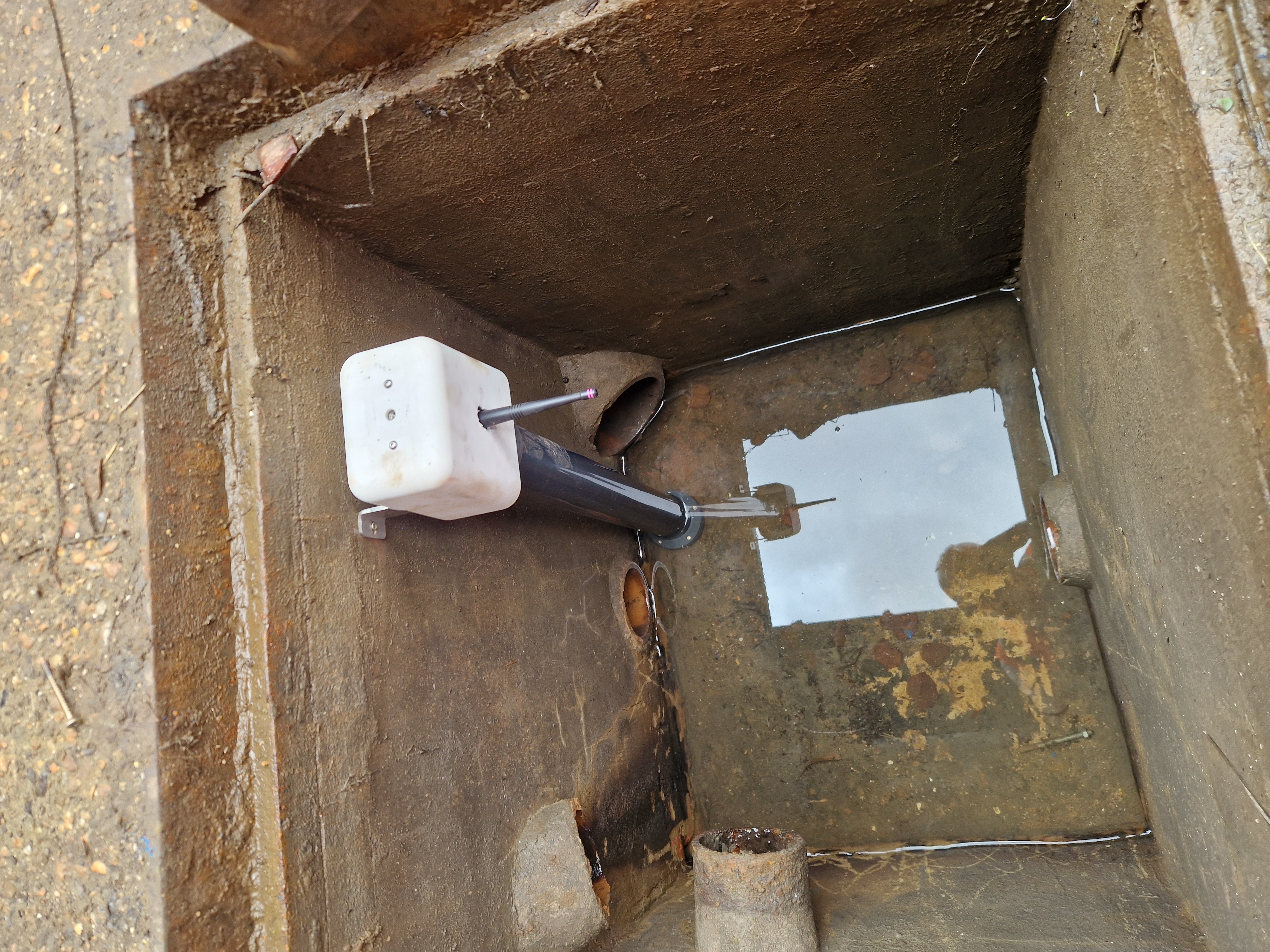
Water level monitor inside manhole chamber
The battery-powered, long-life water level sensor was installed quickly in an inspection chamber, eliminating the need for complex wiring and reducing the need for further opening of the chamber and therefore supported safer working practices. Predefined trigger levels ensured immediate notifications via SMS and email if water levels exceeded safe thresholds.
This enabled Network Rail to proactively manage drainage risks, providing near real-time alerts and live visual data for informed decision-making. The six-month dataset validated the effectiveness of the drain cleaning and remediation works, ensuring continued protection of a nearby substation.
Stay Ahead of the Weather
Remote monitoring of watercourses and drains is not new. Water level meters, for example, are routinely used to provide data on changing conditions in locations of interest such as upstream of a vulnerable bridge or residential area. Such devices typically operate on a pre-set schedule however and can therefore miss a short-term event, and where cameras are used, they typically require mains power supply. The Senceive package is both autonomous in terms of power and comms, and considerably more capable in terms of responsiveness and flexibility.
Harnessing these smart monitoring solutions can help you stay one step ahead of the weather—protecting infrastructure and the people who use it.
The drainage monitoring kit includes a drainage bracket and an Optical Displacement Sensor