
Published Fri 12th Sep 2025
Reflections on the growing use of camera technology in remote monitoring
Wireless Monitoring for Railway Slope Failures
Senceive wireless monitoring technology has been used to detect railway slope failures for more than 10 years and is relied upon across the UK network and in a growing list of other countries. Thanks to a close relationship between engineers and surveyors at Network Rail and Senceive, development and improvement has never stopped.
Integrating Remote Cameras into Intelligent Monitoring
An early request was for the addition of a remote camera that could be integrated into the InfraGuard intelligent monitoring solution to help engineers verify the cause of alerts generated by tilt sensors. Since then, a fleet of more than 1000 cameras has provided over six million images in Network Rail’s southern region alone, demonstrating that access to site images has become a crucial part of earthwork management practice.
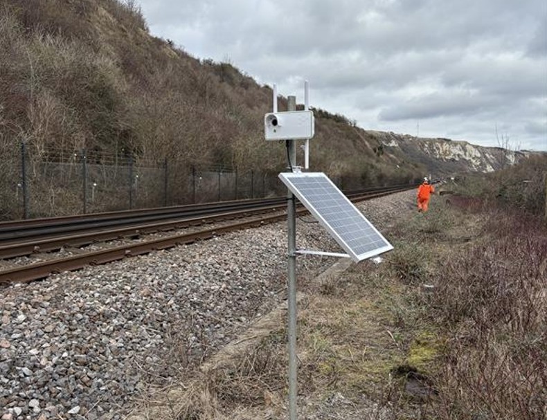
Camera installed as part of an integrated water level monitoring system. Rising water levels detected by a laser sensor will trigger an alert and an image to be transmitted to remote stakeholders.
Introducing the Senceive CameraHub
The Senceive CameraHub represents the third generation of these sophisticated IoT devices. It is engineered to provide fully autonomous (solar powered) imaging in highly demanding conditions. No flash or illumination is permitted on the UK mainline rail network to avoid distracting train drivers, but as every geotechnical engineer knows, most slope failures seem to happen in the depths of the night. The Senceive solution is therefore built around a combination of long exposure and image processing to compensate for lack of ambient light. This is all done utilising the quad-core edge computing power on board the Camerahub, which also compresses each image file before wireless transmission to a 4G communications gateway. From there, image files are transmitted wirelessly from site and made accessible to remote users via the WebMonitor portal. The whole process is typically completed within 3-4 minutes.
Five key functions of the Senceive CameraHub:
- Provides effectively continuous access to site photographs, typically sending a preset number of scheduled images per day, but critically also sending images when requested or when triggered by an event detected by other sensor (e.g. soil movement detected by a tilt meter).
- Operates with no flash or illuminator, complies with railway safety regulations, including Network Rail Product Acceptance.
- Delivers long-range high-resolution images (resolving a football-sized object at a distance of 50 metres).
- Functions as part of an integrated, multi-sensor wireless system that can monitor various structural and geotechnical parameters.
- Clearshot technology removes dust, ice and moisture from lens.
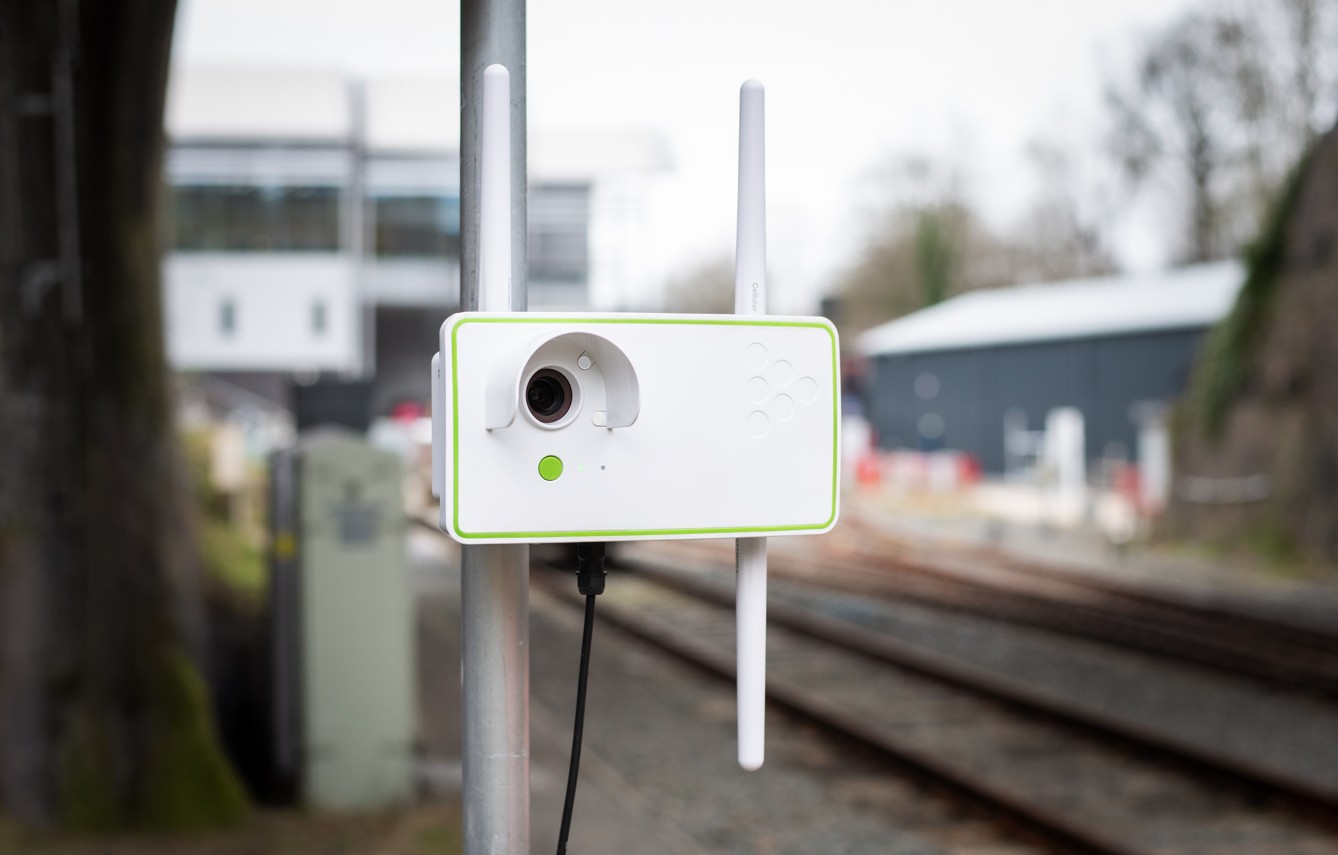
The Senceive CameraHub is the third generation of cellular camera developed for use as part of remote monitoring solution, typically used to support slope risk management.
Multi-Sensor Monitoring for Earthworks and Structures
Slope failures typically occur as a result of multiple causal factors; it therefore makes sense to monitor multiple parameters to detect them. The instrumentation and monitoring sector is moving towards integration of multi sensor solutions tailored for applications such as drainage, rockfall and shallow & deep ground movement. In some respects, cameras are just another sensor within these packages but in reality they are much more than that.
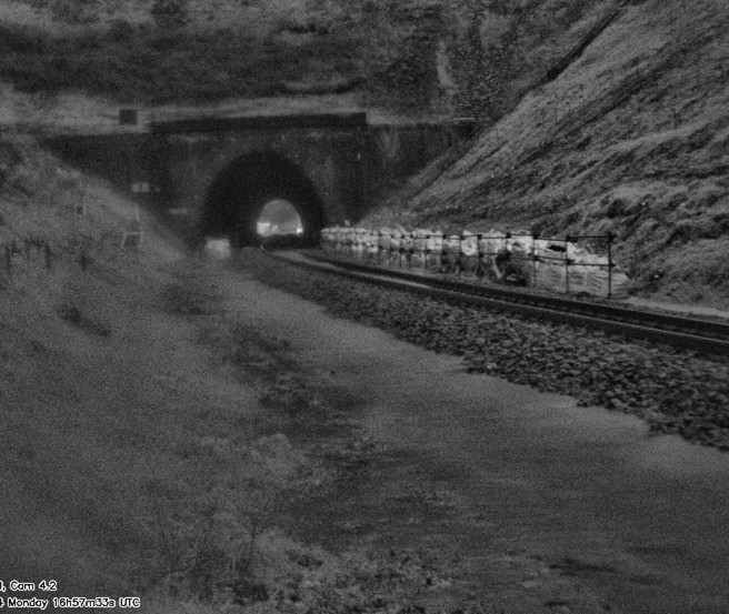
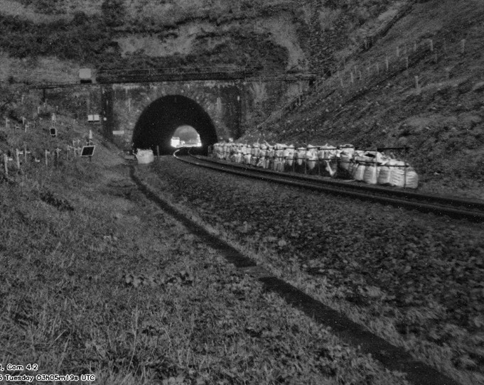
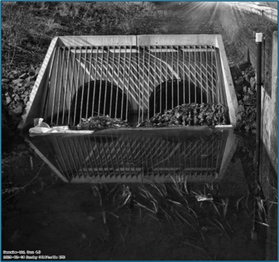
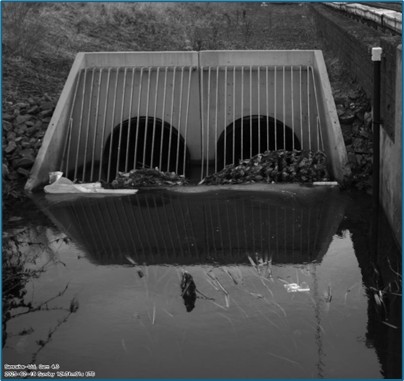
Cameras used to verify alerts and assess risk following ground movement. Note cess flooding in left image, which has dried out a few hours later in right image, but scar above tunnel portal indicates landslip.
Why Cameras Are Crucial in Remote Monitoring:
- Quick verification of events supports time-critical decision making, e.g. determining whether to do nothing, implement speed reductions, or close the line.
- Fewer boots on ballast – fewer site visits mean reduced risk and reduced costs.
- Avoid false alerts – avoid unnecessary disruption and costs.
- Generates a library of images enabling analysis “after the event”.
- Save money on maintenance – most rail networks have identified more “high risk” sites than they can possibly remediate. Monitoring supports the ability to manage these risks and keep the route open.
Expanding Applications of Remote Camera Systems
The main application of our camera systems so far as been early detection of landslips and other slope failures affecting railway cuttings and embankments, but this is changing. Users are now deploying the smart camera kit as part of systems to monitor rockfall and drainage and also using them on other critical infrastructure such as roads.
The Future of Camera Technology in Infrastructure Monitoring
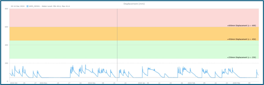
The pace of development is not slowing. Ongoing innovation in processing and analysis enables detection of changes across a sequence of images, enabling the camera to become a monitoring device in its own right. And a final example is the way that the rail operators are beginning to install monitoring data portals in traffic control facilities, so that route controllers can see what is happening on the tracks they are responsible for.