Skip to main content
Explore Eddyfi Technologies Product Lines ▼
Resources
Partners
Blog
News
Translate this page
Contact
Sectors
Sectors
Rail
Construction
Infrastructure
Mining
Integrate your geotechnical & structural sensors
Sensor interface range
Responsive critical asset protection
Find out more
Applications
Applications
Rail track
Slopes
Rockfall
Bridges
Tunnels
Pipelines
Emergency Response Monitoring
Drainage
Dams
Integrate your geotechnical & structural sensors
Sensor interface range
Responsive critical asset protection
Find out more
Products
Products Overview
Imaging & Camera
Tilt Sensors
Wireless Platforms
Optical Displacement Sensor
InfraGuard™
FLX-Rail
Data Comms
Sensor Interface Range
Data Visualisation & Management
Integrate your geotechnical & structural sensors
Sensor interface range
Responsive critical asset protection
Find out more
Case studies
Company
About Us
Careers
Impact
Support
Resources
Partners
Blog
News
Contact
Close menu
X
Translate this page
Search
Explore Eddyfi Technologies Product Lines
▼
Automated Vision Systems
ET & UT Solutions
Nuclear Steam Generators
Remote Monitoring Solutions
Robotics Solutions
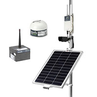
InfraGuard™
Datasheet File
Product Data Sheet - InfraGuard_0.pdf
Datasheet Image
Language
English